
SAM is working on the world’s highest cog system, Manitou and Pikes Peak Cog Railway, in Manitou Springs, CO. Built in 1889, this is the first time the Railway has ever been surveyed. The client determined that the infrastructure needed to be upgraded, including the rails, ties, and passenger cars.
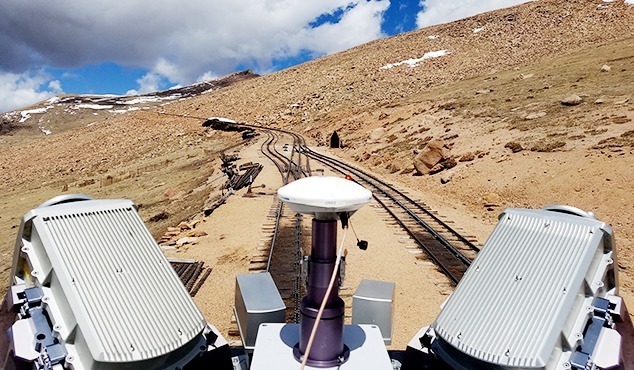
SAM is responsible for surveying and mobile mapping of the Railway for the prime consultant team executing the project. There were several unique challenges on the project, including how to get a LiDAR mobile mapping system mounted on a COG train to the top of a 14,000-foot mountain. Snow storms also delayed the project in the early phases, as the weather averages 30-40 degrees colder at the top of the peak vs. the bottom, and constant winds created snow drifts that had to melt before continuing with remaining tasks. With the track climbing a deep narrow canyon flanked by heavy pine forest, very little GPS positioning for the mobile LiDAR system was available below tree line. There were also hikers and wildlife who interfered with LiDAR control panels.
The SAM team was equipped with best-in-class mobile mapping technology to collect data. Several miles of rail were modeled at 15’ intervals and details were extracted for a surface 60’ wide centered on the track, along with over 20,000 photos collected by the mobile mapping LiDAR system. SAM looks forward to continue supporting the project through its life cycle.


