
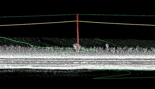
SAM used our mobile LiDAR technology to collect survey data to extract utility pole features and terrain from over 1,000 miles of right-of-way in Missouri. The client was an engineering consulting firm involved in the design of a fiber telecommunications system for rural communities. The first phase of the project involved gathering data on approximately 8,500 utility poles covering more than 350 route miles. Mobile LiDAR was used for the project because using conventional survey methods would have been much more time-consuming and expensive. Furthermore, traditional methods would have included an additional step to transfer the manual data into electronic CAD formats that are part of the downstream workflow. Scanning technology allowed us to accelerate the project time line, capture more accurate and useful information about the utility poles and surrounding terrain, and provide an electronic deliverable that better aligned with the rest of the project workflow. Traditional methods were only required for small areas where obstructions may have inhibited the scanning data collection, where poles were located a long distance from the roadway, or to provide acquisition QC check points.
The primary services provided by SAM included project planning, establishing survey control, data acquisition and calibration, data processing and feature extraction, QA/QC processes, and preparation of PLS_CADD files with geospatially referenced imagery for client delivery. Phase one of the project was successfully completed. The next phase involves expanding the area to include a total of more than 1,000 miles of right-of-way and approximately 25,000 utility poles.


