
Spatial Data Integration & Visualization
Unlock the Potential of Your Data Across Your Enterprise
SAM GeoHub provides a single pane of glass for organizations to visualize and share geospatial and non-geospatial data across their enterprise. It delivers a unified platform that provides a complete view of enterprise assets combining unstructured and structured data in a single source of trusted AI ready data

Share a single source of accurate and trusted data
Leverage the value of your investment in data collection by seamlessly extending access to your entire organization.
Deliverable storage & download capability including large file formats.
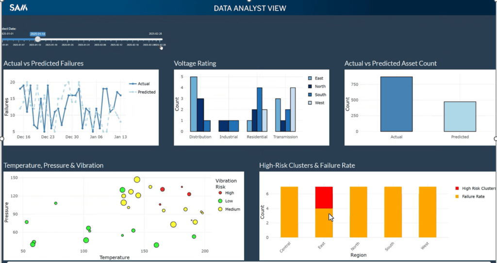
Visualize all data formats concurrently in a single map interface.
Secure Single Sign On integration. Full activity log for audit and security.
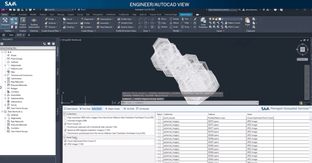
Search and access data directly from within native applications
- Autocad
- OpenRoads
- PLS-CADD
- GIS
- PowerBi / Tableau
- Data Science Tools – Jupyter Notebooks
Integrates with industry leading platforms such as Trimble Connect, Esri ArcGIS Online, Pro & Experience Builder.
Centralized Repository for all your Data Types
Stop hunting for locked and lost data on file servers and portable drives. SAM GeoHub stores all data types in one secure, accessible and searchable location
- Point Cloud / Lidar
- Oriented Imagery
- Nadir Imagery
- Spherical “360” Imagery
- Video inc. 8K
- Infrared
- Geodatabases / GIS Features
- IFC
- Field Inspections Reports
Single Trusted Source of Artificial Intelligence & Machine Learning Ready Data
Orchestrated, relevant and properly formatted data ready for artificial intelligence and machine learning. Enabling data science teams to spend more time creating insights
Built on Spatio Temporal Asset Catalog (STAC) technology all data is spatially and temporally indexed making it fully searchable by location, date, asset and more
Metadata is the cornerstone of AI ready data. SAM GeoHub stores all raw data and meta data adding intelligence to previously dumb data
Run AI inference and store results on data stored in SAM GeoHub
Build bespoke applications that access data stored in SAM GeoHub including Esri experience builder, dashboards & spatial analytics
Why Sam?
SAM has built a reputation as a trusted, knowledgeable, and innovative partner.
As a leading provider of geospatial data for decision support, SAM serves utilities, transportation, and infrastructure-focused clients. With fifty offices, we are the largest, most technically advanced professional Managed Geospatial Service™ (MGS™) in North America. We use innovative technology to capture and analyze infrastructure and environmental conditions with unmatched speed and accuracy, delivering business insights that ensure the safety, sustainability, and reliability of critical infrastructure for our partners.
See GridWorks™ for Yourself
Confidently Power Ahead When You’re Backed by Expertise
Contact us to see how SAM GeoHub can redefine your program management.