
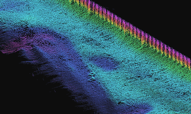
SAM completed a multi-beam sonar bathymetric survey in support of a Texas Parks and Wildlife Department project to rehabilitate a sheet pile bulkhead at the San Jacinto Monument. The project is located alongside the Houston Ship Channel in LaPorte, Harris County, Texas. The bulkhead was designed to stabilize the shoreline of the San Jacinto Battleground Historic Park. A high-density point cloud of submerged terrain elevations was acquired using a RESON 7125 Multi-Beam Sonar operating at a frequency of 400 kHz. The sounder was tilted at a 15-degree angle from horizontal, providing coverage of the bulkhead to within 1.5 feet of the water surface. Sounding positions were compensated for the motion of the multi-beam receiver in all axes of movement using a CODA / Octopus F190 Inertial Motion Unit (IMU). Depths were converted to NAVD88 elevations based on water levels from NOAA’s Lynchburg Tide Gauge. Deliverables included electronic files of a cleaned and edited xyz point cloud in ASCII format and a bathymetric contour map in AutoCAD format. The data density averaged 300 soundings per square foot. Results of the multi-beam survey assisted project engineers in planning dive inspection work and in designing repairs of the sheet pile bulkhead. The dive inspection schedule dictated a rapid response for delivery of bathymetric data. Areas of potential interest were identified from the high-density bathymetry, allowing divers to conduct a targeted structural assessment. The survey identified intact remains of a submerged 1930’s bulkhead fronting each end of the existing structure. Knowledge of the earlier structure’s presence prior to dive inspection ensured that divers’ efforts were planned appropriately.
An article on this project appeared in the newsletter for the Texas Chapter American Shore and Beach Preservation Association. Read More


